
Dosiero:Krt 1510 full.jpg

Fonta dosiero (4 555 × 3 292 rastrumeroj, dosiera grandeco: 1,81 MB, MIME-tipo: image/jpeg)
Resumo
| Priskribo |
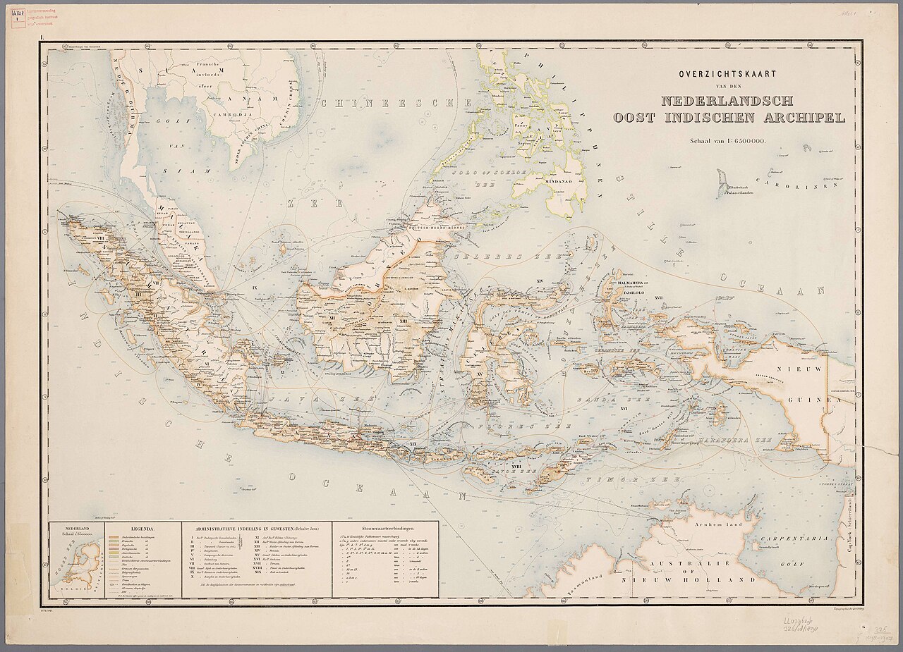
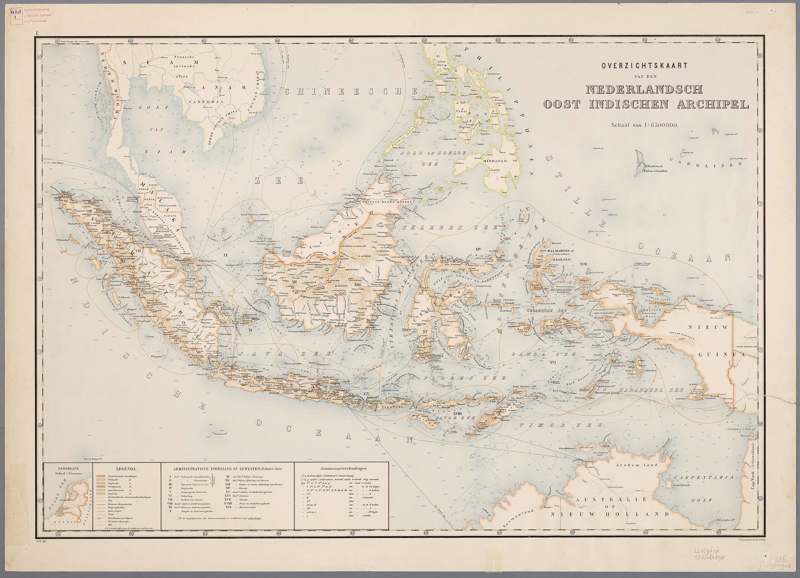
Nederlands: Atlas van Nederlandsch Oost-Indië / samengest. door Topographisch Bureau te Batavia van 1897-1904 |
| Dato | inter 1897 kaj 1904 |
| Fonto | https://vu.contentdm.oclc.org/digital/collection/krt/id/1510 or https://digitalcollections.universiteitleiden.nl/view/item/2014658 |
| Aŭtoro | Topographisch Bureau, Batavia |
| Ceteraj versioj |
.jpg)
.jpg)


|
Tiu ĉi verko estas publika havaĵo en tiuj landoj, kies kopirajtado validas por longo de vivo plus 70 jaroj aŭ malpli. | |
| Estis konkludite ke uzon de ĉi tiu dosiero limigas neniu konata aŭtorrajta leĝo, kio inkluzivas ĉiujn rilatajn kaj apudajn rajtojn. | |
Dosiera historio
Klaku daton/tempon por vidi la dosieron kia ĝi aspektis tiam.
| Dato/tempo | Bildeto | Dimensioj | Uzanto | Komento | |
|---|---|---|---|---|---|
| nuna | 11:54, 27 jul. 2024 | | 4 555 × 3 292 (1,81 MB) | Zacwill | Reverted to version as of 06:41, 8 August 2023 (UTC) the "restored" file has been transformatively altered and is thus not in the public domain |
| 06:44, 8 aŭg. 2023 |  | 4 000 × 3 000 (14,13 MB) | Bennylin | restored and enchanced by u/helloVizart | |
| 06:41, 8 aŭg. 2023 |  | 4 555 × 3 292 (1,81 MB) | Bennylin | {{Information |Description={{nl|Atlas van Nederlandsch Oost-Indië / samengest. door Topographisch Bureau te Batavia van 1897-1904<br /> 1. Overzichtskaart van den Nederlandsch Oost Indischen Archipel}} |Source=https://vu.contentdm.oclc.org/digital/collection/krt/id/1510 |Date=1897-1904 |Author=Topographisch Bureau, Batavia |Permission= |other_versions= }} {{PD-old}} Category:Old maps of Indonesia |
Dosiera uzado
La jena paĝo ligas al ĉi tiu dosiero:
Suma uzado de la dosiero
La jenaj aliaj vikioj utiligas ĉi tiun dosieron:
- Uzado en arz.wikipedia.org
- Uzado en ast.wikipedia.org
- Uzado en ca.wikipedia.org
- Uzado en cy.wikipedia.org
- Uzado en dag.wikipedia.org
- Uzado en de.wikivoyage.org
- Uzado en diq.wikipedia.org
- Uzado en el.wikipedia.org
- Uzado en en.wikivoyage.org
- Uzado en eo.wikipedia.org
- Uzado en fr.wikinews.org
- Uzado en fr.wikivoyage.org
- Uzado en ga.wikipedia.org
- Uzado en gl.wikipedia.org
- Uzado en ha.wikipedia.org
- Uzado en he.wikipedia.org
- Uzado en ia.wikipedia.org
- Uzado en incubator.wikimedia.org
- Uzado en it.wikipedia.org
- Uzado en kab.wikipedia.org
- Uzado en kcg.wikipedia.org
- Uzado en kl.wikipedia.org
- Uzado en ks.wikipedia.org
- Uzado en nqo.wikipedia.org
- Uzado en pcm.wikipedia.org
- Uzado en rue.wikipedia.org
- Uzado en tl.wikipedia.org
- Uzado en tly.wikipedia.org
- Uzado en tr.wikiquote.org
- Uzado en vec.wikipedia.org
- Uzado en www.wikidata.org
- Q252
- Wikidata:WikiProject Movies/Numbers
- Wikidata:WikiProject Movies/Numbers/Most frequent P840
- Wikidata:WikiProject Movies/Numbers/Most frequent P915
- User:Zygimantus/Wikidata lists/Example2
- Wikidata:List of 1000 articles every Wikipedia should have
- Wikidata:WikiProject sum of all paintings/Top work locations
- User:Spinster/ASC Leiden Thesaurus
- Wikidata:WikiCite/Wikidata lists/Main subjects of publications with unidentified authors
- User:Walkuraxx/ASC Leiden Thesaurus