
Dosiero:Cloudscape Over the Philippine Sea.jpg
Fonta dosiero (4 928 × 3 280 rastrumeroj, dosiera grandeco: 4,86 MB, MIME-tipo: image/jpeg)
Resumo
| Priskribo |
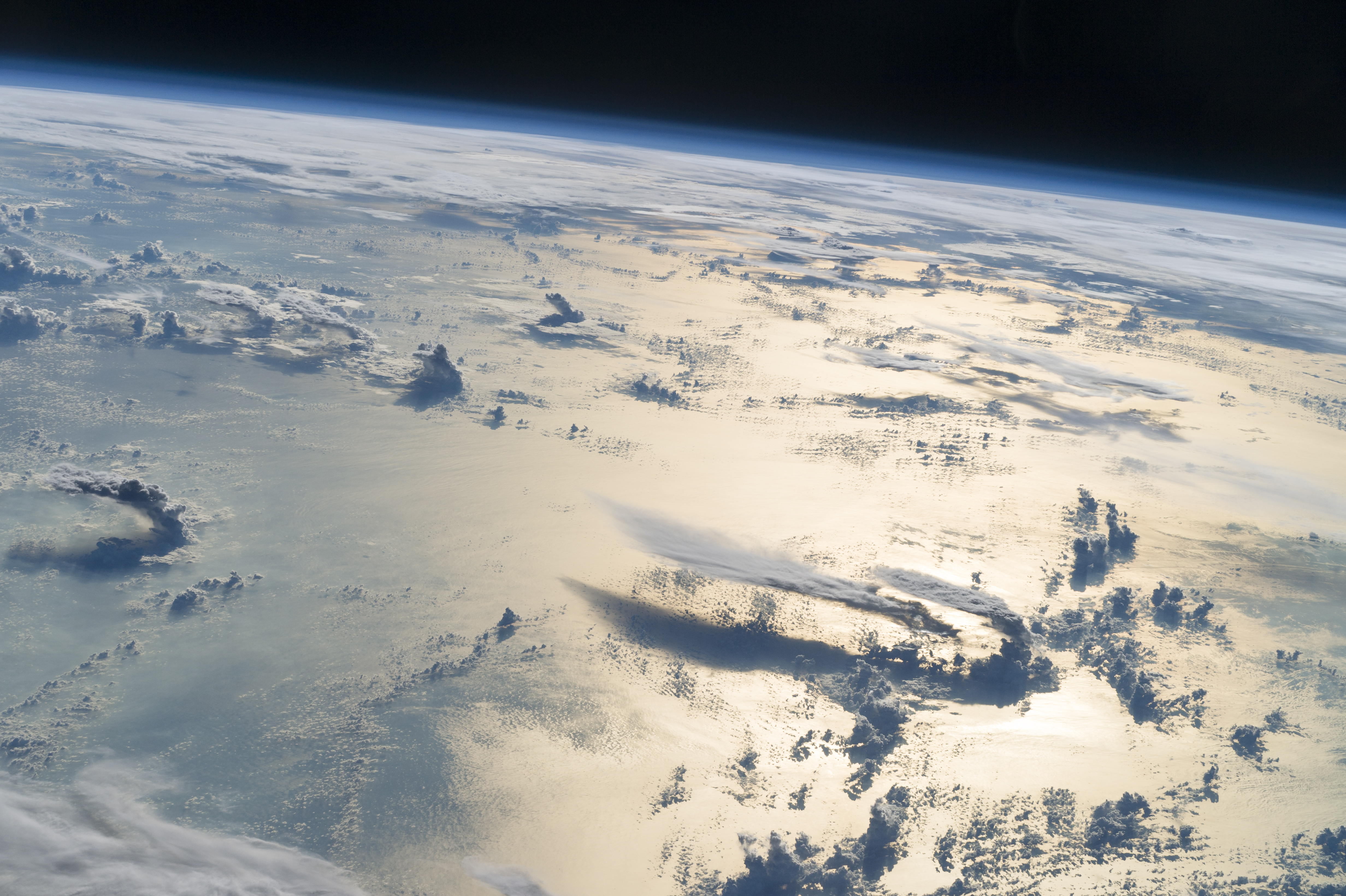
English: Flying over the Philippine Sea, an astronaut looked toward the horizon from the International Space Station and shot this photograph of three-dimensional clouds, the thin blue envelope of the atmosphere, and the blackness of space.
Français : Photographie d'une portion de la Terre prise depuis la Station spatiale internationale, lors du survol de la mer des Philippines. La lumière du soleil en fin d'après-midi fait ressortir un paysage de nuages qui semblent être en trois dimensions. La photographie montre aussi la fine couche bleue de l'atmosphère, et la noirceur de l'espace.
Prendre une photo en se tournant vers le soleil est une technique utilisée par les astronautes pour accentuer l'effet de 3D des reliefs et des nuages, grâce à leur ombre portée. En haut à droite de l'image, près de l'horizon, une grande masse nuageuse cache des iles du nord des Philippines. En bas à droite, deux gros nuages d'orage prennent forme, près d'un troisième. Ils ont une longue traîne, ressemblant à une enclume, qui s'étend à une centaine de kilomètres vers le sud.Polski: rzelatując nad Morzem Filipińskim kosmonauta z Międzynarodowej Stacji Kosmicznej spojrzał w kierunku horyzontu i wykonał tę fotografię trójwymiarowych chmur, cienkiej, niebieskiej powłoki atmosferycznej oraz czerni kosmosu.
Български: Прелитайки над Филипинско море, един космонавт поглежда към хоризонта от борда на Международната космическа станция и прави снимка на тези триизмерни облаци, тънката синя обвивка на атмосферата и тъмнеещия се космос. Късното следобедно слънце осветява обширна ивица от морската повърхност от дясната страна на снимката. В областта, простираща се към хоризонта, обширен слой облаци засенчва островите в северната част на Филипините (тук в горната дясна част на изображнието). Снимането срещу слънцето е техника, използвана от астронавтите в открития космос, за да се акцентира върху триизмерността на пейзажа и облачната обвивка, което се постига благодарение на сенките, които тази техника откроява. Два големи гръмоносни облака се издигат един до друг (тук в долната дясна част на изображението). Дългите им опашки, известни като подкови заради формата им, се простират на около 100 km на юг. Подковите се образуват, когато облаците се издигнат високо в атмосферата и достигнат покриващите ѝ слоеве, намиращи се на хиляди метри надморска височина. Покриващите атмосферни слоеве възпират по-нататъшното издигане на облаците, отклонявайки въздушните течения хоризонтално, а това оформя облачните маси като подкова.
Čeština: Fotografie oblačnosti nad Filipínským mořem pořízená z Mezinárodní vesmírné stanice (ISS) dne 25. června 2016.
Español: Vista satelital del mar de Filipinas desde la Estación Espacial Internacional que muestra una capa de nubes, la fina envoltura azul de la atmósfera y la oscuridad del espacio. El sol de la tarde ilumina una amplia franja de la superficie del mar. En la distancia hacia el horizonte (en el fondo a la derecha), una capa de nubes cubre la región de las islas del norte de Filipinas. Dos grandes nubarrones (cumulonimbus) se elevan uno al lado del otro (en la imagen inferior derecha). Tienen largas colas, también conocidas como yunques por su forma, que se extienden casi 100 km hacia el sur. Los yunques se forman cuando las nubes de tormentas suben en la atmósfera y alcanzan una "capa tapadora", a menudo a miles de metros sobre el nivel del mar. Esta capa detiene el crecimiento hacia arriba de la nube, desviando las corrientes de aire horizontalmente para formar yunques. Fotografiar en la dirección del sol es una técnica que permite acentuar el aspecto tridimensional del paisaje y de las nubes por las sombras que proyectan.
Magyar: Látkép a Nemzetközi Űrállomásról a Filippínó-tenger felett. A délutáni napfény széles sávban tükröződik a tengeren. A horizont felé a távolban nagyrészt felhőréteg fedi a Fülöp-szigetek északi részét. A kép jobb alsó részén két nagy zivatarfelhő emelkedik egymás mellett, közel 100 kilométerre déli irányba elnyúlva
Italiano: Il cielo sopra il mare delle Filippine visto dalla Stazione Spaziale Internazionale. Il sole del tardo pomeriggio illumina il mare sul lato destro dell'immagine, mentre verso l'orizzonte delle nubi oscurano le isole nella parte settentrionale delle Filippine (in alto a destra). Scattare guardando il sole è una tecnica fotografica usata dagli astronauti per accentuare l'aspetto tridimensionale delle terre e delle nubi, grazie alle ombre che queste generano.
Nederlands: Op deze vanuit het internationaal ruimtestation ISS gemaakte foto zijn de Filipijnenzee, wolken en de dampkring zichtbaar
Português: Mar das Filipinas fotografado por um astronauta a bordo da Estação Espacial Internacional em 25 de junho de 2016. |
| Dato | |
| Fonto | NASA |
| Aŭtoro | NASA |
| Pozicio de la fotilo | | Tiu cxi bildo kaj pliaj sur OpenStreetMap |
|---|
This image or video was catalogued by Johnson Space Center of the United States National Aeronautics and Space Administration (NASA) under Photo ID: ISS048-E-10018. This tag does not indicate the copyright status of the attached work. A normal copyright tag is still required. See Commons:Licensing. Other languages:
|
Assessment
|
This image was selected as picture of the day on Wikimedia Commons for 25 May 2017. It was captioned as follows: English: Flying over the Philippine Sea, an astronaut looked toward the horizon from the International Space Station and shot this photograph of three-dimensional clouds, the thin blue envelope of the atmosphere, and the blackness of space. The late afternoon sun brightens a broad swath of the sea surface on the right side of the image. In the distance towards the horizon, a region-wide layer of clouds mostly obscures islands in the northern Philippines (at image top right). Looking toward the sun to capture an image is a special technique used by astronauts to accentuate the three dimensions of landscapes and cloudscapes due to shadows cast by these features. Two large thunderclouds rise next to one another (at image lower right). These have long tails, also known as anvils from their shape, that stretch nearly 100 km to the south. Anvils form when thunderstorm clouds rise high into the atmosphere and reach a “capping layer,” often thousands of meters (tens of thousands of feet) above sea level. Capping layers stop the upward growth of a cloud, deflecting air currents horizontally to form anvils. Other languages:
Čeština: Fotografie oblačnosti nad Filipínským mořem pořízená z Mezinárodní vesmírné stanice (ISS) dne 25. června 2016. English: Flying over the Philippine Sea, an astronaut looked toward the horizon from the International Space Station and shot this photograph of three-dimensional clouds, the thin blue envelope of the atmosphere, and the blackness of space. The late afternoon sun brightens a broad swath of the sea surface on the right side of the image. In the distance towards the horizon, a region-wide layer of clouds mostly obscures islands in the northern Philippines (at image top right). Looking toward the sun to capture an image is a special technique used by astronauts to accentuate the three dimensions of landscapes and cloudscapes due to shadows cast by these features. Two large thunderclouds rise next to one another (at image lower right). These have long tails, also known as anvils from their shape, that stretch nearly 100 km to the south. Anvils form when thunderstorm clouds rise high into the atmosphere and reach a “capping layer,” often thousands of meters (tens of thousands of feet) above sea level. Capping layers stop the upward growth of a cloud, deflecting air currents horizontally to form anvils. Español: Vista satelital del mar de Filipinas desde la Estación Espacial Internacional que muestra una capa de nubes, la fina envoltura azul de la atmósfera y la oscuridad del espacio. El sol de la tarde ilumina una amplia franja de la superficie del mar. En la distancia hacia el horizonte (en el fondo a la derecha), una capa de nubes cubre la región de las islas del norte de Filipinas. Dos grandes nubarrones (cumulonimbus) se elevan uno al lado del otro (en la imagen inferior derecha). Tienen largas colas, también conocidas como yunques por su forma, que se extienden casi 100 km hacia el sur. Los yunques se forman cuando las nubes de tormentas suben en la atmósfera y alcanzan una "capa tapadora", a menudo a miles de metros sobre el nivel del mar. Esta capa detiene el crecimiento hacia arriba de la nube, desviando las corrientes de aire horizontalmente para formar yunques. Fotografiar en la dirección del sol es una técnica que permite acentuar el aspecto tridimensional del paisaje y de las nubes por las sombras que proyectan. Français : Photographie d'une portion de la Terre prise depuis la Station spatiale internationale, lors du survol de la mer des Philippines. La lumière du soleil en fin d'après-midi fait ressortir un paysage de nuages qui semblent être en trois dimensions. La photographie montre aussi la fine couche bleue de l'atmosphère, et la noirceur de l'espace.
Prendre une photo en se tournant vers le soleil est une technique utilisée par les astronautes pour accentuer l'effet de 3D des reliefs et des nuages, grâce à leur ombre portée. En haut à droite de l'image, près de l'horizon, une grande masse nuageuse cache des iles du nord des Philippines. En bas à droite, deux gros nuages d'orage prennent forme, près d'un troisième. Ils ont une longue traîne, ressemblant à une enclume, qui s'étend à une centaine de kilomètres vers le sud.Italiano: Il cielo sopra il mare delle Filippine visto dalla Stazione Spaziale Internazionale. Il sole del tardo pomeriggio illumina il mare sul lato destro dell'immagine, mentre verso l'orizzonte delle nubi oscurano le isole nella parte settentrionale delle Filippine (in alto a destra). Scattare guardando il sole è una tecnica fotografica usata dagli astronauti per accentuare l'aspetto tridimensionale delle terre e delle nubi, grazie alle ombre che queste generano. Magyar: Látkép a Nemzetközi Űrállomásról a Filippínó-tenger felett. A délutáni napfény széles sávban tükröződik a tengeren. A horizont felé a távolban nagyrészt felhőréteg fedi a Fülöp-szigetek északi részét. A kép jobb alsó részén két nagy zivatarfelhő emelkedik egymás mellett, közel 100 kilométerre déli irányba elnyúlva Nederlands: Op deze vanuit het internationaal ruimtestation ISS gemaakte foto zijn de Filipijnenzee, wolken en de dampkring zichtbaar Polski: Przelatując nad Morzem Filipińskim kosmonauta z Międzynarodowej Stacji Kosmicznej spojrzał w kierunku horyzontu i wykonał tę fotografię trójwymiarowych chmur, cienkiej, niebieskiej powłoki atmosferycznej oraz czerni kosmosu. Português: Mar das Filipinas fotografado por um astronauta a bordo da Estação Espacial Internacional em 25 de junho de 2016. Български: Прелитайки над Филипинско море, един космонавт поглежда към хоризонта от борда на Международната космическа станция и прави снимка на тези триизмерни облаци, тънката синя обвивка на атмосферата и тъмнеещия се космос. Късното следобедно слънце осветява обширна ивица от морската повърхност от дясната страна на снимката. В областта, простираща се към хоризонта, обширен слой облаци засенчва островите в северната част на Филипините (тук в горната дясна част на изображнието). Снимането срещу слънцето е техника, използвана от астронавтите в открития космос, за да се акцентира върху триизмерността на пейзажа и облачната обвивка, което се постига благодарение на сенките, които тази техника откроява. Два големи гръмоносни облака се издигат един до друг (тук в долната дясна част на изображението). Дългите им опашки, известни като подкови заради формата им, се простират на около 100 km на юг. Подковите се образуват, когато облаците се издигнат високо в атмосферата и достигнат покриващите ѝ слоеве, намиращи се на хиляди метри надморска височина. Покриващите атмосферни слоеве възпират по-нататъшното издигане на облаците, отклонявайки въздушните течения хоризонтално, а това оформя облачните маси като подкова. |
This image was selected as picture of the day on Bengali Wikipedia.
|
Permesiloj:
| La ĉi-supra dosiero estas publika havaĵo, ĉar ĝi apartenas al NASA. La kopirajta regularo de NASA asertas, ke "ĉiuj dokumentoj de NASA estas publika havaĵo, se ne estas donata kontraŭa deklaro". | ||
 |
Atentu:
|
Dosiera historio
Klaku daton/tempon por vidi la dosieron kia ĝi aspektis tiam.
| Dato/tempo | Bildeto | Dimensioj | Uzanto | Komento | |
|---|---|---|---|---|---|
| nuna | 11:04, 17 nov. 2016 | | 4 928 × 3 280 (4,86 MB) | Originalwana | {{Information |Description ={{en|1=Flying over the Philippine Sea, an astronaut looked toward the horizon from the International Space Station and shot this photograph of three-dimensional clouds, the thin blue envelope of the atmosphere, and the bl... |
Dosiera uzado
Neniu paĝo ligas al ĉi tiu dosiero.
Suma uzado de la dosiero
La jenaj aliaj vikioj utiligas ĉi tiun dosieron:
- Uzado en af.wikipedia.org
- Uzado en av.wikipedia.org
- Uzado en be-tarask.wikipedia.org
- Uzado en bn.wikipedia.org
- Uzado en bn.wikibooks.org
- Uzado en ca.wikipedia.org
- Uzado en crh.wikipedia.org
- Uzado en cv.wikipedia.org
- Uzado en el.wikipedia.org
- Uzado en en.wikipedia.org
- Uzado en fa.wikibooks.org
- Uzado en fj.wikipedia.org
- Uzado en gl.wikipedia.org
- Uzado en hu.wikipedia.org
- Uzado en hy.wikipedia.org
- Uzado en hy.wikibooks.org
- Uzado en id.wikipedia.org
- Uzado en it.wiktionary.org
- Uzado en ka.wikipedia.org
- Uzado en ko.wikipedia.org
- Uzado en krc.wikipedia.org
- Uzado en lbe.wikipedia.org
- Uzado en lez.wikipedia.org
- Uzado en mdf.wikipedia.org
- Uzado en mhr.wikipedia.org
- Uzado en mk.wikipedia.org
- Uzado en ml.wikipedia.org
- Uzado en os.wikipedia.org
- Uzado en pt.wikipedia.org
- Uzado en ru.wikipedia.org
- Uzado en ru.wikinews.org
- Uzado en sah.wikipedia.org
- Uzado en sc.wikipedia.org
- Uzado en sk.wikipedia.org
- Uzado en sq.wikipedia.org
- Uzado en sr.wikipedia.org
- Uzado en tyv.wikipedia.org
- Uzado en udm.wikipedia.org
- Uzado en uk.wikipedia.org
- Uzado en vep.wikipedia.org
- Uzado en www.wikidata.org
- Uzado en xal.wikipedia.org
Vidi plian ĝeneralan uzadon de ĉi tiu dosiero.